Tailored Travel and Tours
Africa
Tailored Travel and Tours
Africa
Hwange National Park (formerly Wankie Game Reserve) is the largest game reserve in Zimbabwe. The park lies in the west, on the main road between Bulawayo and the widely noted Victoria Falls and near to Dete. The Park hosts over 100 mammal and 400 bird species, including 19 large herbivores and eight large carnivores. All Zimbabwe's specially protected animals are to be found in Hwange and it is the only protected area where gemsbok and brown hyena occur in reasonable numbers.
Click to see our Hwange
destinations
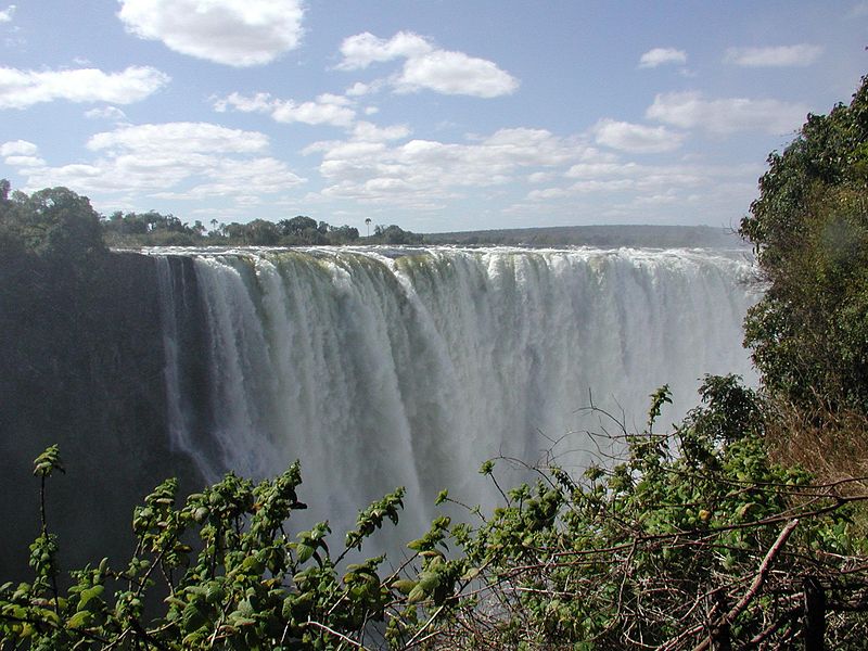
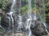
David Livingstone, the Scottish missionary and explorer, is believed to have been the first European to view Victoria Falls on 16 November 1855 from what is now known as Livingstone Island, one of two land masses in the middle of the river, immediately upstream from the falls on the Zambian side. Livingstone named his discovery in honour of Queen Victoria, but the indigenous name, Mosi-oa-Tunya—"the smoke that thunders"—continues in common usage as well. The nearby national park in Zambia, for example, is named Mosi-oa-Tunya,whereas the national park and town on the Zimbabwean shore are both named Victoria Falls. The entire volume of the Zambezi River pours through the First Gorge's 110-meter-wide (360 ft) exit for a distance of about 150 meters (500 ft), then enters a zigzagging series of gorges designated by the order in which the river reaches them.
Click to see our Victoria Falls destinations
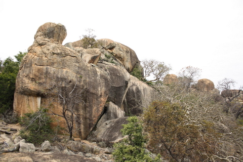
The Matobo National Park forms the core of the Matobo or Matopos Hills, an area of granite kopjes and wooded valleys commencing some 35 kilometres south of Bulawayo, southern Zimbabwe. The hills were formed over 2 billion years ago with granite being forced to the surface, this has eroded to produce smooth "whaleback dwalas" and broken kopjes, strewn with boulders and interspersed with thickets of vegetation. Mzilikazi, founder of the Ndebele nation, gave the area its name, meaning 'Bald Heads'.
The Hills cover an area of
about 3100 km², of which 424 km² is National Park, the
remainder being largely communal land and a small proportion of
commercial farmland. The park extends along the Thuli, Mtshelele,
Maleme and Mpopoma river valleys. Part of the national park is set
aside as a 100 km² game park, which has been stocked with game
including the white rhinoceros. The highest point in the hills is
the promontory named Gulati (1549 m) just outside the north-eastern
corner of the park.
Matobo Hills destinations coming soon!!
It is located in Chimanimani
District, Manicaland Province, in southeastern Zimbabwe, close to
the border with Mozambique. The town lies approximately 120
kilometres (75 mi), by road, south of Mutare, the location of
the provincial headquarters. Its location lies approximately 365
kilometres (227 mi), by road, southeast of Harare, the capital
of Zimbabwe and the largest city in that country
Click to see
our Chimanimani destinations
Selous is a village in Mashonaland West province in Zimbabwe. It lies not far from Harare on the main Harare to Bulawayo road.
It is named after the British explorer and hunter Frederick Selous.
In 1985, novelist Tom Robbins wrote a column for Esquire detailing his tumultuous travels to reach the village entitled "The Day The Earth Spit Warthogs."
Click to see our Selous
destinations
The town was founded in 1890 and was the first large settlement to be established by the Pioneer Column of the BSAC which makes it the oldest town in Zimbabwe. It was named Fort Victoria after Queen Victoria.
The province is largely populated by members of the Karanga tribe, who are the most populous tribe in Zimbabwe, and are a sub-group of the Shona speaking tribes that also include the Zezuru, Manyika and Ndau. Masvingo province, known before 1982 as Victoria province, is in the drier lowveldt area in the south of Zimbabwe. The boundaries were changed slightly in the 1980s. From white settlement until 2000 most of the area was devoted to cattle ranching, with mining and sugar cane growing (irrigated from Mutirikwi), and communal areas where subsistence farming is carried out. With the land reforms of the early 21st century large scale cattle and mixed farms are being redistributed to small farmers.
Click here to see our Masvingo
destinations
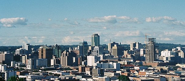
Harare,officially called Salisbury until 1982) is the capital of Zimbabwe. It is the country's seat of government and largest city, with an estimated population of 1,606,000 (2009), with 2,800,000 in its metropolitan area (2006). Administratively, Harare is a metropolitan province, which also incorporates Chitungwiza town and Epworth. It is Zimbabwe's leading financial, commercial, and communications centre, and a trade centre for tobacco, maize, cotton, and citrus fruits. Manufactured goods include textiles, steel and chemicals, and gold is mined in the area. Harare is situated at an elevation of 1483 metres (4865 feet) and its climate falls into the warm temperate category.
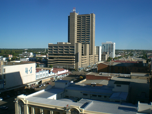
Bulawayo is the second largest city in Zimbabwe after the capital Harare, with, as of the 2012 census, a population of 653,377. It is located in Matabeleland, 439 km (273 mi) southwest of Harare, and is now treated as a separate provincial area from Matabeleland. The capital of Matabeleland North is now Lupane, as Bulawayo is a stand-alone province.
Bulawayo is also known as the 'City of Kings', 'Skies', 'Bluez', 'Bulliesberg' or 'KoNtuthu ziyathunqa' – a SiNdebele word for 'a place of smoky fires'. The majority of the Bulawayo's population belongs to the Ndebele ethnic and language group.
Bulawayo has long been and is
still regarded as the industrial and business capital of Zimbabwe
and is home to the National Railways of Zimbabwe because of its
strategic position near Botswana and South Africa. It is the
nearest large city to Hwange National Park, Matopo National Park
and Victoria Falls.
Click to see our
Bulawayo destinations
Matusadona boasts a unique combination of pristine and rugged wilderness, together with the water frontage of Lake Kariba. It is one of the last remaining sanctuaries of the endangered Black Rhinoceros. It is commonly recognized as having the second largest concentration of wild lions in Africa after Ngorongoro Crater. Its relatively poor accessibility by road and extremely harsh internal network of roads keep the crowds and traffic low - it is accessible by boat from Kariba and from the Bumi Hills airstrip.
Matusadona National Park is one of several protected wildlife areas with shorelines on Lake Kariba. Some 338,000 acres (1370 km²) in area, it is bounded on the west by the Ume river and on the east by the Sanyati River. Two-thirds of it lies south of the Zambezi Escarpment formed by the 1968 foot (600 m) high Matusadona Hills from which it takes its name.
Info on countries excerpts from Wikepedia.org in accordance with the CREATIVE COMMONS ATTRIBUTIONS SHARE-ALIKE LICENSE
Bulawayo
Zimbawe
Cell:
263 773 266 997


Copyright © Love that Safari 2014. All Rights Reserved.